

The Siege of Sarajevo 1992–1996
Emerging directly from the lived experience of the siege, originally hand-drawn, the map is now reimagined as an interactive platform that not only depicts life and death under siege but also deepens understanding of survival and resilience among the citizens of Sarajevo.
READ MORE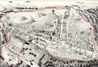
Emerging directly from the lived experience of the siege, this cartographic project documents the physical and social geography of survival in Sarajevo between 1992 and 1996. Combining first-hand testimonies with military maps and photographic records, it charts sniper zones, the altered urban landscape, water collection points, survival gardens, key sites, anti-sniper protection, hospitals, improvised transport routes, venues for cultural events, and pedestrian passages.
Originally hand-drawn, the map is now reimagined as an interactive platform that not only depicts life and death under siege but also deepens understanding of survival and resilience among the citizens of Sarajevo. The digital map enables users to explore designated locations and access layered content on specific sites and themes. Drawing on archival materials from across FAMA projects, the map integrates multiple sources into a single, navigable interface as part of a dedicated knowledge transfer module.
Among the many attempts to visualise history, this map stands out because of the uniqueness of Sarajevo’s experience: a European city at the end of the twentieth century found itself under the longest siege in the history of warfare. For four years, residents were unable to leave the city, which remained under the global media spotlight 24 hours a day.
The Survival [Siege] Map was created based on documents and photographs taken during the blockade, in an effort to capture, within a single image, the transformed geography of a city cut off from the world, even as it remained under the global media’s gaze. The map is a testament to a city that survived by building an entirely new civilisation upon the ruins of the old, relying on recycling, solar energy, water purification tablets, and satellite communications. It details every aspect of survival and explains how key urban infrastructure adapted under siege. The map reveals hidden pathways, secret tunnels, and special movement corridors devised to escape constant sniper fire. It shows how parks became gardens, roses were replaced by corn, electricity by medieval lamps, central heating by handmade stoves, and running water by distant collection points accessed with canisters. Recreation became running under sniper fire; nutrition came from backyard crops; television was replaced by live conversation; and art became a form of resistance.
For future generations studying the siege and the fall of Yugoslavia, this map will provide essential insights into the city’s geography and the conditions shaped by its prolonged isolation.
From the Survival Map editorial published in 1996:
"The capital of Bosnia and Herzegovina, Sarajevo, was attacked on the 5th April 1992. The city in the Miljacka River valley is surrounded by mountains, where 260 tanks, 120 mortars, and a great number of smaller-calibre weapons were placed, pointed towards the city. The Yugoslav National Army, backed by local terrorists, encircled the city and began to tighten the noose around its 300,000 inhabitants. On the 2nd May 1992, the city was completely closed off. A part of it was occupied, while the part that could not be conquered was exposed to gunfire and artillery shells. Every day, the city was hit with 4,000 rounds whose targets included hospitals, museums, mosques, churches, schools, synagogues, libraries, the city maternity hospital, and queues for bread and water. The aggressor destroyed the main post office, and the water, electricity and gas lines were cut off. The food was soon gone. Cemeteries began to spread. On the 26th February 1996, the northern entrance to the city opened, releasing Vogošča and Ilijaš, and Sarajevo was officially declared an open city. After the Dayton Agreement and the arrival of IFOR, the aggressor started leaving the occupied areas of the city. They looted, burned and destroyed everything behind. On the 19th March 1996, the aggressor left Grbavica – the last city area to be returned to the B&H Government by the Dayton Peace Agreement. The siege lasted from the 2nd May 1992 to the 26th February 1996, or 1395 days – it was the longest siege in modern history."
Users can move freely across the map to explore its visual content. By clicking on designated icons, a “content section” opens, providing additional insight into the selected site/topic through text, photographs, and videos. Each “content section” contains seven universal categories:
| Site | Provides background information on the selected location and its altered or adapted function during the siege. |
|---|---|
| Macro Story | An editorially curated narrative that documents individual resilience, innovation, and creativity within a specific thematic context, drawing on materials from the FAMA Collection. |
| Video Guide | A documentary-based collection organised by themes, showing how the citizens of Sarajevo responded to the mechanism of terror through ingenuity and creativity, strengthening resilience. |
| Resilience | Offers additional insight into individual and collective resilience, highlighting work, creativity and innovation as methods of survival. |
| Photo Archive | Photographs from the FAMA Archives related to the selected site and its broader thematic context. |
| Video Oral History | Selected interviews from FAMA’s video oral history collection, connected to the site, event, and wider topic associated with that location. |
| Note | Although each “content section” includes seven categories, the types of content available may vary by site or theme. |

